Overview
Project Years: 1992, 1993, 1994, 1995, 1996, 1997, 1998, 1999, 2000, 2001, 2002, 2003, 2004, 2005, 2006, 2007
The Stroud Preserve riparian reforestation project is a demonstration of the three-zone Riparian Forest Buffer System (RFBS) developed by the U.S.D.A. Forest Service.
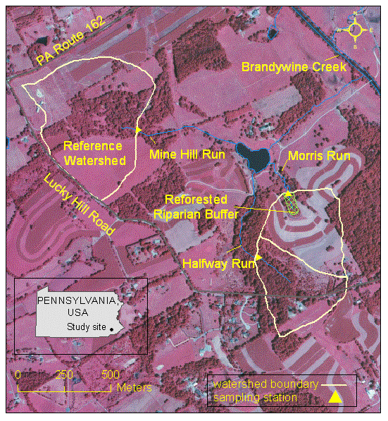
Initiated in 1992, the project involves three experimental agricultural watersheds in the Stroud Preserve, a southeastern Pennsylvania farm protected by conservation easements. The streams are in the drainage of the Brandywine River, which flows into the Delaware Estuary.
Prior to 1992, all three watersheds were primarily in crop production (maize, soybeans, hay) under a soil conservation plan including contouring and crop rotation. Water quality was compromised by elevated nutrients and suspended sediments.
Objectives
The primary objectives of this project are to:
- evaluate the non-point source reductions of the RFBS in the relatively high-relief terrain of the Mid-Atlantic Piedmont
- assess the time required after reforestation to achieve significant mitigation
- establish specific guidelines for planting and managing forest buffers zones in the mid-Atlantic region.
The RFBS consists of: Zone 1, a streamside strip (~ 5 m) of permanent woody vegetation for stream habitat protection; Zone 2, an 18-20 m strip of managed forest upslope from Zone 2; and Zone 3, a 6-10 m wide grass filter strip. The RFBS was established between 1992 and 1994 in a 16-ha watershed (Morris Run) that is primarily in row crop production. Zone 1 included existing streambank trees; Zone 2 was converted from hay and crops to hardwood seedlings; and a level-lip spreader (to disperse concentrated overland flow) was constructed in Zone 3. A second treatment watershed (Half Way Run) was taken out of agricultural production and reforested in its entirety. The third watershed (Mine Hill Run) is being maintained in agricultural production comparable to that of Morris Run, as a long-term reference watershed.
The monitoring design uses paired watersheds supplemented by mass balance estimates of nutrient removal by the riparian forest buffer. Water quality monitoring for nutrients and suspended solids includes grab samples collected every 14 days from all three streams, intensive sampling storm runoff eight times a year (Morris Run and Mine Hill Run), sampling of overland flow (Morris Run), and quarterly sampling of groundwater (Morris Run).
Project Area
The project is being carried out within the Stroud Preserve, a 197-hectare tract in Chester County, Pennsylvania that is held in conservation easements that assure control over land-use in perpetuity. The area of the riparian forest buffer system is approximately 1 hectare of the 16.2 ha of the Morris Run watershed. The location of the sampling station at Morris Run is 39°56’ 41″ N, 75°39’13″W.
Relevant Hydrologic, Geologic, and Meteorological Factors
The average annual precipitation is 115 mm (45 inches). Soils on the Preserve are mainly typic hapludults, but those in the riparian areas are aquic fragiudults. A weathered rock or saprolyte extends to a typical depth of 5-7 m with a bedrock consisting mainly of fractured schist. Slopes average about 10%.
Land Use
All but a few hectares of the Morris Run watershed are maintained in contoured strips under a crop rotation program established by the U.S.D.A. Natural Resources Conservation Service (NRCS). The primary crops are maize, soybeans, and hay (alfalfa). Records are being kept of all fertilizer applications, and of crop yields.
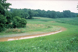
Most of the watershed of Mine Hill Run, the reference watershed, is planted in alfalfa, maize, and soybeans, also under NRCS conservation tillage. A sparsely forested, brushy zone extends 50-200 m from the stream. Land use in this watershed is being maintained without alteration.
The Half Way Run Watershed was in production for row crops and hay prior to 1992 when it was reforested with hardwood seedlings.
Water Resource Type and Size
Morris Run, Mine Hill Run, and Half Way Run are perennial headwater streams in watersheds of 16.2, 36.1, and 15.1 hectares, respectively. They flow into the Brandywine River, which has a 750-km watershed, and is a tributary to the Delaware Estuary.
Water Uses and Impairments
The Brandywine River provides varied water supply and recreational uses and is classified for warm water and migratory fishes in its lower reaches, trout stocking and cold water fishes in various upper reaches. Agricultural sources contribute to elevated nutrient concentrations and sediment loads.
Pollutant Sources
Agricultural fertilizers and atmospheric deposition are the primary sources for elevated exports of nitrogen from the basins. Erosion from tilled fields is the primary source of sediment export. Both erosion and fertilization contribute to elevated phosphorus exports.
Water Quality Objectives
Primary objectives of this project are to: 1) demonstrate the effectiveness of riparian reforestation, when used in conjunction with sound nutrient management and erosion control practices on uplands, in reducing non-point source pollution from agricultural sources and 2) to establish specific guidelines for planting and managing forest buffers zones in the mid-Atlantic region.
Project Time Frame
- Initiation of routine water chemistry sampling: Jan 1992
- Planting of riparian zone in hardwood seedlings: Apr 1992
- Installation of level spreader: May 1994
- NMP Monitoring Project: Apr 1997-Mar 2007
Nonpoint Source Control Strategy
A riparian forest buffer system was established in Morris Run (the treatment watershed) in April of 1992, in accordance with the specification published by the U.S.D.A. Forest Service (Welsch 1991, Publication NA-PR-07-91). Seedlings of Sugar Maple, Red Oak, Tulip Poplar, White Ash, Black Walnut, and Trembling Aspen were planted in a zone extending 23 meters (75 feet) from the stream bank on each side and upslope from its source. Prior to the planting, the buffer area consisted of mowed grass, some tilled area, and a narrow riparian strip (3-10 m) of hardwood trees and brush. Maintenance of the riparian buffer includes replacement of mortality (drought and deer damage), use of tree-tubes and wire tree protectors, and annual application of glyphosate around each tree.
An additional 6 meters (minimum) beyond the reforested buffer is maintained as grassland, representing “Zone 3” of the Riparian Buffer specification. In accordance with this specification, the grassland zone was contoured in late May 1994 to form a level-lip spreader, designed by the NRCS. The purpose of the spreader is to intercept surface runoff, which is delivered to the buffer via grassed waterways, and to release the runoff to the forested buffer as dispersed sheet flow in order to minimize erosion within the buffer.
Other nonpoint source control measures applicable to both the treatment and control watersheds include contoured strips, waterways, and crop rotations in accordance with a soil conservation plan developed by the NRCS.
Water Quality Monitoring
The monitoring program is based on a paired watershed design. Although the riparian forest buffer was established in the first year of monitoring, the first several years (prior to rapid tree growth) serve as a calibration period to establish the pre-implementation comparison between the treatment and reference watersheds. To supplement the paired watershed design, nutrient and sediment retention by the riparian buffer are estimated by mass balance, using data from groundwater monitoring wells and overland flow collectors.
Parameters Measured
- Suspended solids
- Precipitation
- Volatile Solids
- Streamflow
- Dissolved nitrate and nitrite
- Groundwater level
- Dissolved ammonia
- Streamwater temperature
- Dissolved organic nitrogen, (discontinued 4/02)
- Basal area of woody vegetation within riparian zone
- Total phosphorus
- Total dissolved phosphorus, (discontinued 4/02)
- Dissolved orthophosphate
- Dissolved organic carbon, (discontinued 4/02)
- Chloride
- pH
- Conductivity
Sampling Scheme
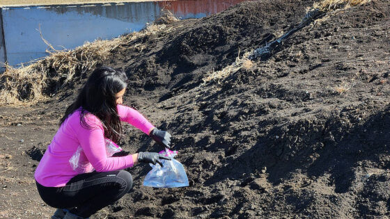
Streamwater samples are collected every 14 days throughout the year from all three streams. Discharge is continuously monitored at all three streams using v-notch weirs. Intensive sampling of streamwater during runoff events is conducted eight times annually from Morris Run and Mine Hill Run. Groundwater is sampled quarterly from 27 monitoring wells. Overland flow in Morris Run watershed is collected from four events annually.
Data Analysis and Management
Data were entered, verified, stored, and analyzed using the SAS Information System. Data will also be entered into the USEPA STORET system and the NonPoint Source Management System.
Data analysis included:
- Comparisons of concentrations and annual exports of nitrogen, phosphorus, and suspended solids from each of the three watersheds, testing the hypothesis that these parameters are reduced by riparian reforestation
- Mass-balance estimates of nitrogen, phosphorus, and sediment retention within the reforested riparian buffer.
For project results, see pages 10-31 of the project final report.
Funding
Funding was provided by the Pennsylvania Department of Environmental Protection through Section 319 of the Federal Clean Water Act administered by the US Environmental Protection Agency.
The project has received additional financial support for various periods since 1991 from the USDA Forest Service, the Pennsylvania State Bureau of Forestry, and the Chesapeake Bay Program. Technical assistance has been provided by the U.S.D.A. Forest Service, the Pennsylvania State Bureau of Forestry, and the USDA Natural Resource Conservation Service.