FOR IMMEDIATE RELEASE: August 26, 2011
CONTACTS: Diane Huskinson, Stroud Water Research Center
MEDIA ADVISORY
WHAT: Scientists to Collect Water Quality and Climate Change Data From Hurricane Irene
WHEN & WHERE: Friday, August 26, 2011 1–3 p.m. – USGS Station 01479000 on White Clay Creek near Newark, Del. and throughout southern Chester County, Pa.
Avondale, Pa. – While Hurricane Irene has officials along the East Coast preparing for mass evacuations, scientists at Stroud Water Research Center and the University of Delaware are grabbing their best data collection tools and heading straight for the storm’s path.
It’s a rare opportunity for the storm-chasing scientists, as Irene threatens to be the biggest hurricane to hit the Northeast since 1985. Stroud Center scientist Anthony Aufdenkampe explains, “It rains on average once per week, or 15 percent of the year, but streams and rivers move most of their annual loads on those days. The bigger the storm, the greater the disproportionate load, so you might have a single 100-year storm event move 25 percent of the material for an entire decade. This is important because fresh waters and the carbon they transport play a major role in the global cycling of greenhouse gases.”
Therefore, Irene holds the possibility for collecting data that could reveal much about how, and how much, soil erosion into rivers might eventually bury carbon and sequester it from acting as a greenhouse gas in the atmosphere. This is a primary goal of the Christina River Basin Critical Zone Observatory (CRB-CZO), funded by a grant from the National Science Foundation (NSF). The CRB-CZO is at the forefront of scientific research on integrating how human impacts to the hydrological, mineral, and carbon cycles might feed back to climate change.
“We are hypothesizing,” says Aufdenkampe, “that big storms are a major player in determining what happens to the carbon in a leaf for example. Does it go back into the atmosphere or does it get buried for decades, centuries, or millennia? That’s the key to global warming and climate change.”
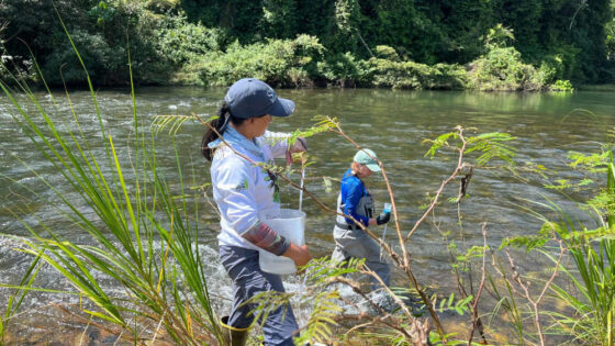
The answers will be in the data. Aufdenkampe and colleagues will visit sites along White Clay Creek and Brandywine Creek beginning Friday to set up equipment to collect floodwaters throughout the entire storm.
And thanks to innovative tools compiled using relatively inexpensive open-source electronic hardware, they won’t have to wait around for Irene. Engineer Shannon Hicks of Stroud Water Research Center has put together automatic water samplers that can be triggered remotely via cell phone.
“By watching real-time sensor data streaming to the Internet, at precisely the right moment we can fill the barrels of water we need for our more sophisticated analyses. Had a storm like this hit 5 or 10 years ago, we wouldn’t have been able to gather this type of data. But now with open-source hardware and software, anything’s possible. We’re only limited by our imagination,” Aufdenkampe says.